Category: Mapping
Scarfie Flats is part of The Great Map of New Zealand Stories
If you’ve ever visited a place you’ve previously read about in a book then you’ll know that it adds a special something to your experience of the physical space – much like reading about a place after having visited it causes you to recall you impressions and experience of being there.
Mapping places mentioned in books is, in fact, a thing, and The Great Map of New Zealand Stories is doing it here. So if you’re interested in reading about a particular area, check out the map, zoom in and connect with a story in a book which will give you an insight into that place. The addresses for each of the main stories from Scarfie Flats in Dunedin has been mapped in The Great Map of New Zealand Stories.
https://commutingbook.maps.arcgis.com/apps/StoryMapCrowdsource/index.html?appid=49a3620f4b7648ceac888aa265400feb
Mapping and meshblock data
Caveat: This post was written a year ago and since then Meshblock has been updated.
____________
Cameron Prebble @cameron_prebble has created a tool called Mashblock @MashblockNZ that displays data from Statistics NZ in a clean, digestible, graphic format. The data presented is from 2013 but there is an option via a drop down menu to select 2006 or 2001 data aswell.
@SarahLibrarina thanks for your support. All of our data is from the 2013 Census. We are working on improving our graphics for gender data.
— mashblock◆ (@MashblockNZ) June 14, 2014
Mashblock makes it simple for me to see what is happening within a meshblock and area unit in terms of demographic distribution. The main area units in Dunedin that have the highest student aged populations are:
North East valley, usual resident population
- 47.33% Males
- 52.67% Females
Dunedin North, 3465 usual resident population
- 44.46% Male [n=2,184]
- 55.54% Females [n=2,430]
Otago University, 5082 usual resident population
- 45.43% Males [n=2,310]
- 55.47% Females [n=2775]
Where it gets interesting for me is at meshblock level (the smallest level of measurment) and the gender demographics within that small area. Let’s take Castle Street as an example: The meshblock between Duke and Howe Streets has a fairly even distribution of male and female residents (54.84% males : 45.16% females). It should be noted that this meshblock includes a postgraduate hall of residence. However crossing Howe Street to the next meshblock reveals a much higher female population (30.77% males : 69.23% females). The adjoining mesh block which includes Selwyn College, also has a high female population (40% males : 60% females). Females are also in higher proportion in the two meshblocks in Leith Street Nth.
Meshblocks where we see more student aged males residing are west of George Street (70.83% males : 29.17% females), …
Areas that traditionally display a higher level of flat naming are Clyde Street and Hyde Streets. Looking at the gender distribution it is easy to see that on Clyde Street, south of Albany, there are significantly more males than females (62.50% males : 37.50% females) where Hyde Street has more of a balance (52.38% males : 47.62% females) in 2013, and has done so in 2006 and 2001 too.
Links
Mashblock
Cameron’s website
Hear Vaughan Davis talk about Mashblock, his ‘site of the week’ (16 May 2014)
More flats added to the Online Casino Real Money NZ Map #flatnames
Even MORE flats have been added to the Project Flats Map in the last couple of days. I’m on a mission to get this map up to date. To me the most important thing is that I can visually represent all of the named student flats in Dunedin overtime, those I’ve either seen and documented myself, that I have read about in memoirs, or have been reported in various means.
Background
I built this map on 12 March 2009, back when playing with Google Maps was reasonably new and novel. It’s been viewed over 11,800 times since then. After some initial confused forays into the new Google Maps that was released this year, I’ve reverted back to the original version which seems to work the way I want it to, which is to map address, add detail to that record, and then display the embedded map in this blog.
How to find your flat
Google Maps does not list addresses either numerically or alphabetically, and I have ascertained no way of being able to do this. So the easiest way to find your address is to open the Dunedin Flat Names Map, do a find search (command F – rather than use the search box) and type in the address details. Here’s an example: 654 Castle Street.
Click on the address which should be highlighted in the list on the left, and up will pop the details (on the right) with a flat name and, hopefully, a photo. If the flat name has a clickable link, this will take you to a Online Casino Real Money NZ Flickr or Facebook page where you can make a comment or view some more information about the flat.
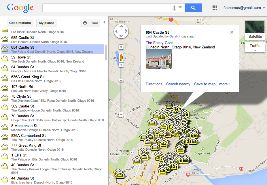
Google Map showing a FInd (command+F) Search for 654 Castle Street. Note the name of the flat is clickable.
Update to the Dunedin Flat Names Google Map #flatnames
I’ve just spent a couple of hours updating the Dunedin Flat Names Google Map – it has LOADS of new flats listed, check it out, and if you find any missing, please let me know the address, name of the flat and year/s it existed with that name.
As always, I’d love to hear your stories and see your pics, either here on via the share your story form on the Project website.
Campus report: can do better
Campus report: can do better
